

The Quiet of a Storm Approaching
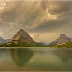
Der 2550 m hohe Grinnell Point erhebt sich über den sonnigen Swiftcurrent Lake in Waterton Glacier. Binnen Minuten zogen bedrohliche Wolken vom Westhorizont herauf. Fernes Donnergrollen erfüllte die Luft und der Himmel färbte sich schwefelgelb. Absolute Windstille kündete die Ruhe vor dem Sturm an. Gipfel um Gipfel verschwanden aus dem Blickfeld als der Starkniederschlag der Sturmfront ins Tal herein zog. Das Gewitter hinterließ eine zentimeterdicke Hagelspur. Innerhalb von 30 Minuten verwandelte sich das Bild in eine Winterlandschaft während die Temperaturen um mehrere Grad fielen. Ausgelöst wurde der Sturm durch einen abgeschnürten Kaltlufttropfen der oberen Atmosphäre. Die globalen Strömungsmuster der oberen Atmosphäre beeinflussen das Wetter am Boden. Tröge bringen kalte Luft und tiefen Druck weit nach Süden. Der Kaltlufttropfen verlagerte sich ostwärts und sorgte für Unwetter beim Kontakt mit der vorderseitigen Warmluft.
August 2008
Canon 20D, Canon EF-S 10-22mm, f/16, ½ Sek, 100 ASA, Stativ
Mehr Information unter
www.lichtjahre.eu
Where Geoscience Meets Art - Die Ästhetik der Geowissenschaft
Ein Projekt, das die Schönheit der Natur dokumentiert
und zum Verständnis der Geowissenschaften beiträgt
----------------------------------------------------------------------------------------
During a late summer afternoon 8366 ft (2550 m) high Grinnell Point was towering over sunny Swiftcurrent Lake in Waterton Glacier. Within minutes sinister clouds approached the Many Glacier area from the western horizon. Distant thunder filled the sky while the clouds turned sulphureous. The winds calmed down leaving the valley in total silence. The quiet of a storm approaching. One by one the distant peaks vanished from the horizon as the squall lines precipitation moved in. First drops reached the lake. Finally the thunderstorm crossed the lake leaving behind a thick layer of hail. Within 30 minutes the summertime landscape turn into a winter scenery with temperatures dropping significantly. This high impact weather event was triggered by an upper level cut off low moving in from Canada. The global upper-air flow pattern affects the weather at the surface. A trough brings cold air and low pressure to the south. A pinched off trough moves slowly eastward bringing severe weather where it comes in contact with the surrounding warm air mass.
August 2008
Canon 20D, Canon EF-S 10-22mm, f/16, 1/2sec, ISO 100, tripod
More information:
www.lichtjahre.eu
Where Geoscience Meets Art
A project that documents Nature's beauty
and enhances understanding of geosciences
Comentarios
6


Información
| Sección | Natur: Bergseen |
| Vistas | 7.764 |
| Publicada | |
| idioma |

|
| Licencia |
Le ha gustado a

Insertar foto
Incluye el siguiente enlace en un comentario, descripción o en un mensaje para mostrar esta foto.
El enlace ha sido copiado...
Por favor haz clic en el enlace y utiliza la combinación de teclas "Ctrl" [Win] o "Cmd" [Mac] para copiar el enlace.
Imhof Reto 14/03/2009 16:24
Tolles Bild,super diese Stimmung,Lg Reto
Wenke Seemann Bln 13/03/2009 17:04
genailes licht!gWenke
Uwe Einig 13/03/2009 12:53
Eine sehr schöne Landschaftsaufnahme! Tolle Bearbeitung!Aiblinger 13/03/2009 11:22
Klasse Stimmung und traum LichtFein
Lg
Monika Schieferstein 13/03/2009 10:41
Sehr schöne Aufnahme...lg Monika
Isabella und Jürgen Sachen 13/03/2009 10:36
Klasse Arbeit.gruß Jürgen