
Eifel Tour
The Eifel is a low mountain range in western Germany and eastern Belgium. It occupies parts of southwestern North Rhine-Westphalia, northwestern Rhineland-Palatinate and the south of the German-speaking Community of Belgium.
The Eifel is part of the Rhenish Massif; within its northern portions lies the Eifel National Park.
The Eifel and its western continuation into Belgium, the Ardennes, are a part of the Variscan mountain belt and belong to the Rhenish Massif (Rheinisches Schiefergebirge).
The Eifel consists mainly of Devonian slates, sandstones and limestones, laid down in an ocean south of the Old Red Continent[2] and folded and overthrust in the Variscan orogeny. The Eifel geological structures like main folds and overthrusts can be traced in a SW-NE direction far beyond the Rhine valley.
In the Tertiary and Quaternary geological eras, the Eifel was a site of extensive volcanic activity. Some of the hills are volcanic vents. The peculiar circle-shaped lakes (maar) of the volcanic regions formed in volcanic craters. The last volcanic eruptions in the Laacher See volcanic site took place around 10,000 years ago and generated a huge volume of volcanic ash, now found in thin ash layers in contemporaneous sediments throughout Europe. The volcanism of the Eifel is thought to be partly caused by the Eifel hotspot, a place where hot material from deep in the mantle rises to the surface, and partly by melt-ascent at deep fractures in the Earth's crust.[3] Research has shown that the volcanism is still active; the Eifel region is rising by 1–2 mm per year. Historically, the Eifel volcanoes had inactive phases of 10,000 to 20,000 years between active phases, suggesting there is a possibility of future eruptions.[citation needed] Castles
Lage
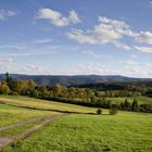
Die Eifel liegt zwischen Aachen im Norden, Trier im Süden und Koblenz im Osten. Sie fällt im Nordosten entlang der Linie Aachen–Düren–Bonn zur Niederrheinischen Bucht ab. Im Osten und Süden wird sie vom Rhein- und Moseltal begrenzt. Westwärts geht sie in Belgien und Luxemburg in die geologisch verwandten Ardennen und das Luxemburger Ösling über. Sie liegt in Rheinland-Pfalz und Nordrhein-Westfalen und berührt den Raum Eupen–Sankt Vith–Luxemburg. Die höchste Erhebung ist der Vulkankegel Hohe Acht (746,9 m). Ursprünglich bezeichnete der karolingische Eifelgau nur annähernd das Gebiet um die Quellen der Flüsse Ahr, Kyll, Urft und Erft. Der Name wurde in jüngerer Zeit auf die gesamte Region übertragen.
Landschaftsformen
Die Eifel gehört zu den Teilen des Rheinischen Schiefergebirges, deren wellige Hochfläche als Rumpfhochland bezeichnet wird, das sich aus dem durch Erosion abgetragenen Urgebirge der variszischen Gebirgsbildungsphase und späterer erneuter Hebung entwickelte. Die Hochfläche durchziehen im westlichen Teil einzelne bis 700 m hohe Bergrücken wie Schneifel und Hohes Venn. Im Ostteil bildeten sich in der Hohen Eifel und der Vulkaneifel aus tertiärem und quartären Vulkanismus einzelne Schlackenvulkane und Basaltkuppen wie die Hohe Acht und der Ernstberg, welche die Hügellandschaft überragen.
Die zur Mosel, Rhein und Maas hin entwässernden Flüsse wie Our, Kyll, Ahr, Brohl und Rur haben sich zum Rand der Eifel hin tief eingeschnitten und bilden größere Täler aus.
Die über 5.300 km² große Eifel wird geografisch in Nord- und Südeifel unterteilt, feingliedriger jedoch in mehrere naturräumliche Landschaften mit teilweise weiteren Untergliederungen.
National- und Naturparks
Seit 2004 ist ein Teil der Nordeifel als Nationalpark Eifel ausgewiesen. Etwa von Norden nach Süden betrachtet liegen in der Eifel vier Naturparks: Rheinland, Hohes Venn-Eifel, Vulkaneifel und Südeifel, wobei der erstgenannte Park nur im Süden in nördliche Eifelausläufer reicht.
Quelle: Wikipedia
Comentarios
9


Información
| Sección | Natur: Vulkanlandschaften |
| Vistas | 1.164 |
| Publicada | |
| idioma |

|
| Licencia |
Exif
| Cámara | Canon EOS 1000D |
| Objetivo | EF-S17-85mm f/4-5.6 IS USM |
| Diafragma | 14 |
| Tiempo de exposición | 1/400 |
| Distancia focal | 17.0 mm |
| ISO | 200 |
Insertar foto
Incluye el siguiente enlace en un comentario, descripción o en un mensaje para mostrar esta foto.
El enlace ha sido copiado...
Por favor haz clic en el enlace y utiliza la combinación de teclas "Ctrl" [Win] o "Cmd" [Mac] para copiar el enlace.
Compartir en Messenger
Incorpora el siguiente enlace en el campo de comentarios de la conversación deseada en Messenger utilizando 'Pegar' para enviar esta imagen en el mensaje.
El enlace ha sido copiado...
Por favor haz clic en el enlace y utiliza la combinación de teclas "Ctrl" [Win] o "Cmd" [Mac] para copiar el enlace.
Julia Wylenzek 21/11/2014 12:27
Genau so wie ich sie kenne und vermisse, seit ich nicht mehr dort wohne! Feines Pano!LG
Maria Weinmann (matewe) 28/10/2014 16:37
Ein tolles Panorama einer einzigartigen Landschaft. LG mariaS. Söllner 22/10/2014 17:54
Ein sehr schön gelungenes Landschaftspanorama...Lg, Sigi
Lana 1 18/10/2014 22:49
Sehr professionell und einzigartig mit dem Blick in die Ferne:)) LG LanaMichael Farnschläder 18/10/2014 22:18
ja, da eifelt es ziemlich ;-))LGM
Rolf Kammler 18/10/2014 20:04
In der Tat: ein bemerkenswertes Panoramabild dieser grandiosen und liebenswerten Eifellandschaft.Liebe Grüße
Rolf
Alfredo Spagnoli 18/10/2014 20:02
Bella Panoramica Mati, complimenti.Ciao, Alfredo
Runzelkorn 18/10/2014 18:46
Gallia est omnis divisa in partes tres, quarum unam incolunt belgae...Altphilologen haben Probleme mit Englisch: Was schreibste da?
Aber schön scheint´s zu sein in der Eifel!
Gruß, Christian
† Reinhard S 18/10/2014 18:33
Schönes Eifelbild !Gerade wegen der Fernsichten liebe ich sie.
Liebe Grüße, Reinhard