

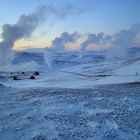
Geothermal Power Plant Krafla
The picture was taken in the afternoon 07-Dec2007
From Wikipedia, the free encyclopedia:
Krafla
Elevation 650 metres (2,133 ft)
Location Iceland
Coordinates 65°44′0″N 16°47′0″W / 65.73333°N 16.78333°W / 65.73333; -16.78333
Type Caldera
Last eruption 1984
Krafla is a caldera of about 10 km in diameter with a 90 km long fissure zone, in the north of Iceland in the Mývatn region. Its highest peak reaches up to 818 m; it has erupted 29 times and it is 2km in depth.
Comentarios
4


Información
| Sección | Viaje: Iceland |
| Vistas | 2.197 |
| Publicada | |
| idioma |

|
| Licencia |
Insertar foto
Incluye el siguiente enlace en un comentario, descripción o en un mensaje para mostrar esta foto.
El enlace ha sido copiado...
Por favor haz clic en el enlace y utiliza la combinación de teclas "Ctrl" [Win] o "Cmd" [Mac] para copiar el enlace.
Compartir en Messenger
Incorpora el siguiente enlace en el campo de comentarios de la conversación deseada en Messenger utilizando 'Pegar' para enviar esta imagen en el mensaje.
El enlace ha sido copiado...
Por favor haz clic en el enlace y utiliza la combinación de teclas "Ctrl" [Win] o "Cmd" [Mac] para copiar el enlace.
Polarfuchs 2 07/03/2009 14:30
Fantastisch!Norman Preißler 06/03/2009 18:18
I like it!Regards, Norman
Gamle Oern 28/02/2009 12:35
Hi Luc,the below description of the location is taken from Wikipedia.
Thanks for your comment
G.O.
Krafla in 1984
Elevation 650 metres (2,133 ft)
Location Iceland
Coordinates 65°44′0″N 16°47′0″W / 65.73333°N 16.78333°W / 65.73333; -16.78333
Type Caldera
Last eruption 1984
Krafla is a caldera of about 10 km in diameter with a 90 km long fissure zone, in the north of Iceland in the Mývatn region. Its highest peak reaches up to 818 m; it has erupted 29 times and it is 2km in depth.
Bernard64 27/02/2009 20:22
Schönes Foto ein wahres Vergnügen für die Bravoaugen freundschaftlich