

Spellbound
Zusätzlich zu den katastrophalen Flutbasalt Lavaausbrüchen vor 17 Millionen Jahren ereigneten sich vor 15.000 bis 13.000 Jahren bis zu 90 weitere katastrophale Sturzflutereignisse in der Columbia River Gorge, am Ende der letzten Eiszeit. Der Eisschild über British Columbia reichte bis in die Berge von Nord Idaho und Nordwest Washington. Das vorrückende Eis füllte das Columbia Becken, zwischen dem Kaskadengebirge und den Rocky Mountains. Dabei blockierte der Eiswall den Clark Fork River. Dieser bildete den Abflusskanal des Eisschildes sowie der Gletscher der Rockies. Dadurch staute sich das Schmelzwasser in den Tälern von Nordwest Montana, wodurch ein riesiger See namens Glacial Lake Missoula entstand. Als an der Eisbarriere das Wasser eine Tiefe von 600 m auf einer Länge von 50 km überstieg, begann der Eisdamm aufzuschwimmen. Tunnel im Eis öffneten sich und der Damm brach binnen Stunden komplett ein. Die resultierende Sturzwasserflut räumte die Columbia River Gorge auf heutige Größe aus. Zuflüsse die in die Schlucht mündeten enden daher heute als Wasserfälle.
August 2008
Canon 20D, Canon EF-S 10-22mm, f/22, 2 Sek, 100 ASA, Stativ
Mehr Information unter
www.lichtjahre.eu
Where Geoscience Meets Art - Die Ästhetik der Geowissenschaft
Ein Projekt, das die Schönheit der Natur dokumentiert
und zum Verständnis der Geowissenschaften beiträgt
----------------------------------------------------------------------------------------
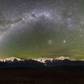
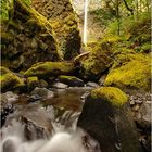
Despite the cataclysmic volcanic flood basalt outpourings 17 millions years ago beautiful Columbia River Gorge set the stage for up to 90 catastrophic events that happened between 15.000 and 13.000 years ago. At that time the ice age was about to come to an end. The large ice sheet over British Columbia advanced into the mountainous terrain of northern Idaho and northeastern Washington slowly filling the Columbia Basin between the Cascade Range and the Rocky Mountains. The advancing ice blocked the Clark Fork River that drained the ice sheet and numerous glaciers in the Rockies. Consequently meltwater backed up into the valleys of northwestern Montana building up a huge lake known as Glacial Lake Missoula. The water reached a depth of about 2000 ft (600 m) where the ice blocked the canyon on a length of 30 miles (50 km). At that time the ice dam began to float opening tunnels for the draining meltwater within hours. Finally the ice dam collapsed resulting in a torrential flood that cut back the canyon walls of the Columbia River Gorge. Rivers flowing into the gorge were left hanging resulting in today’s beautiful waterfalls.
August 2008
Canon 20D, Canon EF-S 10-22mm, f/22, 2 sec, ISO 100, tripod
More information:
www.lichtjahre.eu
Where Geoscience Meets Art
A project that documents Nature's beauty
and enhances understanding of geosciences
Comentarios
1


Información
| Sección | Natur: Wasserfälle |
| Vistas | 6.584 |
| Publicada | |
| idioma |

|
| Licencia |
Le ha gustado a

Insertar foto
Incluye el siguiente enlace en un comentario, descripción o en un mensaje para mostrar esta foto.
El enlace ha sido copiado...
Por favor haz clic en el enlace y utiliza la combinación de teclas "Ctrl" [Win] o "Cmd" [Mac] para copiar el enlace.
ulliman 29/06/2009 12:04
Die Schärfe und auch die Farben gefallen mir sehr gut !!l.g. ulliman